• Home
  • About
    • About
    • Directions
    • Advertising
    • MSR Facebook Group
    • MSR Lost and Found Group
    • Buy Me A Coffee
    • Contact
  • See & Do!
    • The Master List
    • The Best Float Trips
    • Food & Drink
    • Shop Local (Retail)
    • Hiking & Backpacking
    • MSR Swimming Spots
    • Popular Past Posts
    • Fishing Links
    • Catch of a Lifetime
    • The Flying W Bluff
    • Float into Cave Spring
    • Experience the Transition
    • See Rocky Falls
    • Jacks Fork Artesian Well
    • 2024 Total Eclipse
    • Road Trip to Summersville
    • See Kangaroos + a Cave!
    • MSR Paranormal Stories
  • Lodging
    • Upper Current Lodging
    • 2022 Gravel Bar Survey CA
    • 2022 Gravel Bar Survey AP
    • Lower Current Lodging
    • Jacks Fork Lodging
    • Eleven Point Lodging
    • Options with RV Hook-Ups
    • Options that allow Pets
    • Camping Checklist
  • Outfitters
    • Shuttle Rates
    • How the Outfitters Work
    • Upper Current Outfitters
    • Lower Current Outfitters
    • Current Float Schedule
    • Jacks Fork Outfitters
    • Jacks Fork Float Schedule
    • ONSR Horsepower Limits
    • 11 Point Outfitters
    • 11 Point Float Schedule
    • 11 Point Horsepower Limit
    • 11 Pt. Video Tour (19 mi)
  • Maps
    • Buy ONSR Waterproof Map
    • Where is the MSR region?
    • Where are the 3 MSRs?
    • ONSR Zoomable Map
    • Montauk State Park Map
    • Echo Bluff State Park Map
    • Current River S.P. Map
    • Round Spring Map
    • Big Spring Map
    • Current Mile-by -Mile
    • Alley Spring Map
    • Jacks Fork Mile by Mile
    • 11 Point Clickable Map
    • 11 Point River Map
    • 11 Point Mile by Mile
    • 11 Point Travel Guide
  • Weather
    • Missouri Radar Map
    • Upper Current Weather
    • Middle Current Weather
    • Lower Current Weather
    • Jacks Fork Weather
    • Eleven Point Weather
    • Current River Levels
    • Jacks Fork River Levels
    • Eleven Point River Levels
  • Parks
    • Fishing Limits & Restric.
    • ONSR Website
    • Buy ONSR Map
    • ONSR Alerts & Conditions
    • ONSR Facebook Page
    • ONSR Hunting
    • ONSR Photo Gallery
    • ONSR Laws & Policies
    • ATV & Off Road Vehicles
    • Montauk State Park
    • Montauk Campground Tour
    • Montauk State Park Map
    • Montauk S.P. FB Group
    • Montauk Events Calendar
    • 2021 Montauk Talks
    • Current River State Park
    • Current River S.P. Tour
    • Current River S.P. Map
    • Echo Bluff State Park
    • Echo Bluff State Park Map
  • Caves & Springs
    • Current River Caves
    • Jacks Fork Caves
    • Cave Links
    • Devils Well Research
    • Current River Springs
    • Jacks Fork Springs
    • Eleven Point Springs
    • Spring Links
  • Wild Horses & Riding
    • Horseback Riding ONSR
    • Best ONSR Horse Trails
    • ONSR Horse Trails Map
    • Find Missouri Wild Horses
    • Wild Horses Posts & Pics
    • MO Wild Horse League
  • Camping Games
    • Cornhole
    • Tossing Games Forum
    • Camping Games
  • Historical
    • History Topics (MUST SEE)
    • ONSR History
    • Remembering Cedar Grove
    • Shannon County Genealogy
    • Shannon County Videos
    • Shannon County Museum
    • Oregon County Genealogy
    • Traditional Ozark Crafts
    • Place Names
    • Pulltite History
    • Blair Creek - Henry Gore
    • Portrait of Ozarks Part 1
    • Portrait of Ozarks Part 2
    • New Documentary - Filming
  • Polls
    • Most kid friendly stretch
    • Fav Upper Current Stretch
    • Favorite Month to Visit
    • Favorite way to Sleep
    • Preferred Tubing Mileage?
    • Favorite River?
    • Favorite Watercraft?
    • Upper Current Outfitter
    • Jacks Fork Outfitter
    • Eleven Point Outfitter
  • Best Kayak or Canoe?
    • Best Canoe?
    • Best Kayak or Canoe?
    • Sit in or Sit on Kayak?
    • Best 10 ft. Kayak?
    • Kayak Recommendations
    • Best heavy person kayak?
    • Beginner Kayak buying
    • Best place to buy one?
  • Tragedies & Memoriam
    • 1800s Montauk Killing
    • 1884 Jacks Fork Accident
    • 1896 Current Drowning
    • Welch Spring Tragedy
    • 1913 Jacks Fork Drownings
    • 1957 Fremont Devastation
    • 1966 Rescue
    • 2019 Jacks Fork Rescue
    • 2020 Brewer Tragedy
    • Disasters on the River
    • Lightning Tragedy
    • Mayor Jim Anderson
    • Eleanor Maggard
    • Joe Devall
    • Jack Peters
    • Gene Maggard
    • Marcus Maggard
    • Ranger Bill Terry
    • Jerry Richards
  • More
    • Home
    • About
      • About
      • Directions
      • Advertising
      • MSR Facebook Group
      • MSR Lost and Found Group
      • Buy Me A Coffee
      • Contact
    • See & Do!
      • The Master List
      • The Best Float Trips
      • Food & Drink
      • Shop Local (Retail)
      • Hiking & Backpacking
      • MSR Swimming Spots
      • Popular Past Posts
      • Fishing Links
      • Catch of a Lifetime
      • The Flying W Bluff
      • Float into Cave Spring
      • Experience the Transition
      • See Rocky Falls
      • Jacks Fork Artesian Well
      • 2024 Total Eclipse
      • Road Trip to Summersville
      • See Kangaroos + a Cave!
      • MSR Paranormal Stories
    • Lodging
      • Upper Current Lodging
      • 2022 Gravel Bar Survey CA
      • 2022 Gravel Bar Survey AP
      • Lower Current Lodging
      • Jacks Fork Lodging
      • Eleven Point Lodging
      • Options with RV Hook-Ups
      • Options that allow Pets
      • Camping Checklist
    • Outfitters
      • Shuttle Rates
      • How the Outfitters Work
      • Upper Current Outfitters
      • Lower Current Outfitters
      • Current Float Schedule
      • Jacks Fork Outfitters
      • Jacks Fork Float Schedule
      • ONSR Horsepower Limits
      • 11 Point Outfitters
      • 11 Point Float Schedule
      • 11 Point Horsepower Limit
      • 11 Pt. Video Tour (19 mi)
    • Maps
      • Buy ONSR Waterproof Map
      • Where is the MSR region?
      • Where are the 3 MSRs?
      • ONSR Zoomable Map
      • Montauk State Park Map
      • Echo Bluff State Park Map
      • Current River S.P. Map
      • Round Spring Map
      • Big Spring Map
      • Current Mile-by -Mile
      • Alley Spring Map
      • Jacks Fork Mile by Mile
      • 11 Point Clickable Map
      • 11 Point River Map
      • 11 Point Mile by Mile
      • 11 Point Travel Guide
    • Weather
      • Missouri Radar Map
      • Upper Current Weather
      • Middle Current Weather
      • Lower Current Weather
      • Jacks Fork Weather
      • Eleven Point Weather
      • Current River Levels
      • Jacks Fork River Levels
      • Eleven Point River Levels
    • Parks
      • Fishing Limits & Restric.
      • ONSR Website
      • Buy ONSR Map
      • ONSR Alerts & Conditions
      • ONSR Facebook Page
      • ONSR Hunting
      • ONSR Photo Gallery
      • ONSR Laws & Policies
      • ATV & Off Road Vehicles
      • Montauk State Park
      • Montauk Campground Tour
      • Montauk State Park Map
      • Montauk S.P. FB Group
      • Montauk Events Calendar
      • 2021 Montauk Talks
      • Current River State Park
      • Current River S.P. Tour
      • Current River S.P. Map
      • Echo Bluff State Park
      • Echo Bluff State Park Map
    • Caves & Springs
      • Current River Caves
      • Jacks Fork Caves
      • Cave Links
      • Devils Well Research
      • Current River Springs
      • Jacks Fork Springs
      • Eleven Point Springs
      • Spring Links
    • Wild Horses & Riding
      • Horseback Riding ONSR
      • Best ONSR Horse Trails
      • ONSR Horse Trails Map
      • Find Missouri Wild Horses
      • Wild Horses Posts & Pics
      • MO Wild Horse League
    • Camping Games
      • Cornhole
      • Tossing Games Forum
      • Camping Games
    • Historical
      • History Topics (MUST SEE)
      • ONSR History
      • Remembering Cedar Grove
      • Shannon County Genealogy
      • Shannon County Videos
      • Shannon County Museum
      • Oregon County Genealogy
      • Traditional Ozark Crafts
      • Place Names
      • Pulltite History
      • Blair Creek - Henry Gore
      • Portrait of Ozarks Part 1
      • Portrait of Ozarks Part 2
      • New Documentary - Filming
    • Polls
      • Most kid friendly stretch
      • Fav Upper Current Stretch
      • Favorite Month to Visit
      • Favorite way to Sleep
      • Preferred Tubing Mileage?
      • Favorite River?
      • Favorite Watercraft?
      • Upper Current Outfitter
      • Jacks Fork Outfitter
      • Eleven Point Outfitter
    • Best Kayak or Canoe?
      • Best Canoe?
      • Best Kayak or Canoe?
      • Sit in or Sit on Kayak?
      • Best 10 ft. Kayak?
      • Kayak Recommendations
      • Best heavy person kayak?
      • Beginner Kayak buying
      • Best place to buy one?
    • Tragedies & Memoriam
      • 1800s Montauk Killing
      • 1884 Jacks Fork Accident
      • 1896 Current Drowning
      • Welch Spring Tragedy
      • 1913 Jacks Fork Drownings
      • 1957 Fremont Devastation
      • 1966 Rescue
      • 2019 Jacks Fork Rescue
      • 2020 Brewer Tragedy
      • Disasters on the River
      • Lightning Tragedy
      • Mayor Jim Anderson
      • Eleanor Maggard
      • Joe Devall
      • Jack Peters
      • Gene Maggard
      • Marcus Maggard
      • Ranger Bill Terry
      • Jerry Richards

  • Home
  • About
    • About
    • Directions
    • Advertising
    • MSR Facebook Group
    • MSR Lost and Found Group
    • Buy Me A Coffee
    • Contact
  • See & Do!
    • The Master List
    • The Best Float Trips
    • Food & Drink
    • Shop Local (Retail)
    • Hiking & Backpacking
    • MSR Swimming Spots
    • Popular Past Posts
    • Fishing Links
    • Catch of a Lifetime
    • The Flying W Bluff
    • Float into Cave Spring
    • Experience the Transition
    • See Rocky Falls
    • Jacks Fork Artesian Well
    • 2024 Total Eclipse
    • Road Trip to Summersville
    • See Kangaroos + a Cave!
    • MSR Paranormal Stories
  • Lodging
    • Upper Current Lodging
    • 2022 Gravel Bar Survey CA
    • 2022 Gravel Bar Survey AP
    • Lower Current Lodging
    • Jacks Fork Lodging
    • Eleven Point Lodging
    • Options with RV Hook-Ups
    • Options that allow Pets
    • Camping Checklist
  • Outfitters
    • Shuttle Rates
    • How the Outfitters Work
    • Upper Current Outfitters
    • Lower Current Outfitters
    • Current Float Schedule
    • Jacks Fork Outfitters
    • Jacks Fork Float Schedule
    • ONSR Horsepower Limits
    • 11 Point Outfitters
    • 11 Point Float Schedule
    • 11 Point Horsepower Limit
    • 11 Pt. Video Tour (19 mi)
  • Maps
    • Buy ONSR Waterproof Map
    • Where is the MSR region?
    • Where are the 3 MSRs?
    • ONSR Zoomable Map
    • Montauk State Park Map
    • Echo Bluff State Park Map
    • Current River S.P. Map
    • Round Spring Map
    • Big Spring Map
    • Current Mile-by -Mile
    • Alley Spring Map
    • Jacks Fork Mile by Mile
    • 11 Point Clickable Map
    • 11 Point River Map
    • 11 Point Mile by Mile
    • 11 Point Travel Guide
  • Weather
    • Missouri Radar Map
    • Upper Current Weather
    • Middle Current Weather
    • Lower Current Weather
    • Jacks Fork Weather
    • Eleven Point Weather
    • Current River Levels
    • Jacks Fork River Levels
    • Eleven Point River Levels
  • Parks
    • Fishing Limits & Restric.
    • ONSR Website
    • Buy ONSR Map
    • ONSR Alerts & Conditions
    • ONSR Facebook Page
    • ONSR Hunting
    • ONSR Photo Gallery
    • ONSR Laws & Policies
    • ATV & Off Road Vehicles
    • Montauk State Park
    • Montauk Campground Tour
    • Montauk State Park Map
    • Montauk S.P. FB Group
    • Montauk Events Calendar
    • 2021 Montauk Talks
    • Current River State Park
    • Current River S.P. Tour
    • Current River S.P. Map
    • Echo Bluff State Park
    • Echo Bluff State Park Map
  • Caves & Springs
    • Current River Caves
    • Jacks Fork Caves
    • Cave Links
    • Devils Well Research
    • Current River Springs
    • Jacks Fork Springs
    • Eleven Point Springs
    • Spring Links
  • Wild Horses & Riding
    • Horseback Riding ONSR
    • Best ONSR Horse Trails
    • ONSR Horse Trails Map
    • Find Missouri Wild Horses
    • Wild Horses Posts & Pics
    • MO Wild Horse League
  • Camping Games
    • Cornhole
    • Tossing Games Forum
    • Camping Games
  • Historical
    • History Topics (MUST SEE)
    • ONSR History
    • Remembering Cedar Grove
    • Shannon County Genealogy
    • Shannon County Videos
    • Shannon County Museum
    • Oregon County Genealogy
    • Traditional Ozark Crafts
    • Place Names
    • Pulltite History
    • Blair Creek - Henry Gore
    • Portrait of Ozarks Part 1
    • Portrait of Ozarks Part 2
    • New Documentary - Filming
  • Polls
    • Most kid friendly stretch
    • Fav Upper Current Stretch
    • Favorite Month to Visit
    • Favorite way to Sleep
    • Preferred Tubing Mileage?
    • Favorite River?
    • Favorite Watercraft?
    • Upper Current Outfitter
    • Jacks Fork Outfitter
    • Eleven Point Outfitter
  • Best Kayak or Canoe?
    • Best Canoe?
    • Best Kayak or Canoe?
    • Sit in or Sit on Kayak?
    • Best 10 ft. Kayak?
    • Kayak Recommendations
    • Best heavy person kayak?
    • Beginner Kayak buying
    • Best place to buy one?
  • Tragedies & Memoriam
    • 1800s Montauk Killing
    • 1884 Jacks Fork Accident
    • 1896 Current Drowning
    • Welch Spring Tragedy
    • 1913 Jacks Fork Drownings
    • 1957 Fremont Devastation
    • 1966 Rescue
    • 2019 Jacks Fork Rescue
    • 2020 Brewer Tragedy
    • Disasters on the River
    • Lightning Tragedy
    • Mayor Jim Anderson
    • Eleanor Maggard
    • Joe Devall
    • Jack Peters
    • Gene Maggard
    • Marcus Maggard
    • Ranger Bill Terry
    • Jerry Richards

The Best Missouri Scenic Rivers Float Trips

Cave Spring located between Akers Ferry and Pulltite Spring on the upper Current River.

What is the best overall single day float in the Missouri Scenic Rivers region?


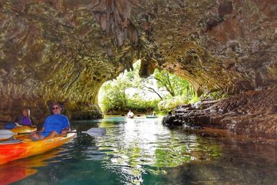
Wow, this is a close one. If it were springtime or the water levels were high enough, then the far upper Jacks Fork 8-mile stretch from Buck Hollow (hwy 17) to Rymers would be a top contender due to its extreme rugged beauty and huge Jam Up Cave, but for a year round float I feel that the best (and most popular) single day float in the Missouri Scenic River region is the 10-mile upper Current River stretch from Akers Ferry to Pulltite Spring campground.  This will average about 6 hours, but if you like to stop a lot and for longer periods to explore and enjoy the river (like me), then it can be turned into an 8 hour trip.  You will average about 2 miles per hour + any stops.  It has just about everything that you could want.   See the Ozark National Scenic Riverways (Current River & Jacks Fork) zoomable map here.  At the beginning you will get to see the car ferry at Akers which is the last 2 car ferry in the state of Missouri.  This river stretch’s centerpiece is the famed Cave Spring …. a large 140 ft. deep spring cave which is a brilliant blue color that you can float into with your watercraft. This is located about 5 miles down on the left in your 10-mile journey. This stretch has a larger number of gravel bars for you to stop (or camp) on. More than on the next stretch from Pulltite to Round Spring.   (Fact: The Eleven Point River has far fewer gravel bars than the Current River, especially above Turners Mill).   This Akers Ferry to Pulltite stretch also has a nice a set of minor rapids which many call the “fun” section of rapids on the upper Current River.  If you don’t like crowds, then avoid this stretch on Saturdays between Memorial Day and Labor Day weekend. The BEST days to float this stretch with the fewest floaters are Tuesdays and Wednesdays.     This stretch does not have any roads within any distance of the stretch of river that you can hear any vehicles, unlike the next stretch from Pulltite to Round Spring which as you get nearer the Round Spring bridge you can hear road traffic. If you would like to float this stretch then I would recommend that you call Current River Canoe Rental located at Pulltite campground. That way your vehicle is right there at the end of the trip near the river waiting for you. The store there opens at 8am and the first bus goes up to Akers about 8:30am, then about every hour or two afterwards through lunchtime.

What is the best float for tubing?


There are 3 stretches that I would recommend. The first is the 6 mile stretch from Alley Spring to Eminence on the Jacks Fork (Call Windy’s Canoe Rental). The next is the 2.5 mile stretch from Welch Spring to Akers Ferry on the upper Current River (Call Aker’s Ferry Canoe Rental). The last is the 1.5 mile stretch from Sinking Creek to the Round Spring bridge on the upper Current River (Call Carrs Canoe Rental).   These are short doable stretches since tubes only go about 1 to 1.5 mile per hour + any stops.   Slower than a canoe or kayak which travels 2 to 2.5 miles per hour + stops.   If you don't mind motor boats, then the lower Current River also has 2 stretches also that are popular for tubers.   The 7 mile stretch from Waymeyer to Van Buren and the 4 mile stretch from Van Buren to Big Spring.  

What is the best overnight float trip?


There are 3, one for each scenic river. My personal favorite is the 18-mile Cedar Grove to Pulltite Spring campground stretch (Call Current River Canoe Rental).  Not only do you get to see Cave Spring, but also Welch Spring and its old hospital ruins.  On the Eleven Point River the 20 mile stretch from Greer Spring to Riverton is nice and the crowds are less than the Current River or Jacks Fork (Call Hufstedlers Canoe Rental).  Keep in mind though that the Eleven Point River has far fewer gravel bars at the other 2 scenic rivers (especially above Turners Mill), but that is negated by its beauty and plethora of sites to see (Turner Mill, springs like at Boze Mill and some awesome rapids to name a few). There are float camps to stay at though on the Eleven Point River for overnighters. Some even do this 20-mile stretch in a day. If you put in early enough in the summer, then it can be done in 8-10 hours.  See the Eleven Point River map here.   If it were the spring-time when the water levels are higher, then I would recommend the far upper Jacks Fork 18 mile trip from Hwy 17 (Buck Hollow) to Bay Creek (Call Harveys Canoe Rental).  

What is the best extended day float trip?


The 44-mile Cedar Grove to Two Rivers or the 51-mile Baptist Access to Two Rivers is the absolute best extended day float. This spectacular 3-day trip has it all …. Caves, springs, rapids, historic sites and more!  Contact Two Rivers Canoe Rental for this trip. The first 8 miles from Baptist to Cedar Grove is trophy trout territory and is low in the summer, but doable year-round. You may have to walk in a few places above Cedar Grove, but it is doable. You will have to portage your watercraft over the lower water bridge at Cedar Grove if you put in at Baptist Access vice putting in at Cedar Grove. Below Round Spring you may encounter an occasional motorboat due to the higher horsepower limit set there between May 1st and Sep. 15th, but that becomes much more prevalent below Two Rivers and the further down river you go toward Van Buren. Between Round Spring and Two Rivers you will not encounter that many floaters, which makes that 18 mile stretch even more awesome!

What IS THE MOST FLOATED SECTION OF the missouri scenic RIVERs?


In the summer months there are actually 3 sections that are equally the most floated (and busiest) sections of river in the Missouri Scenic Rivers region.   On the Jacks Fork the Alley Spring to Eminence, MO 6-mile stretch is super busy, especially on Saturdays.   The same goes for the 10 mile Akers Ferry to Pulltite Spring campground since everyone wants to see Cave Spring.   And lastly, the 8 mile Cedar Grove to Akers Ferry on the upper Current River is highly travelled since many people want to see Welch Spring and the old hospital ruins.   If you don't like crowds, then avoid these 3 sections on Saturdays between Memorial Day and Labor Day weekends.   I personally only float these sections on weekdays for that reason.   If you want to experience smaller crowds on a weekend but still experience amazing views and sites, then go to the lesser floated Eleven Point Missouri Scenic River and float any stretch between Greer Spring and Riverton (Call Hufstedlers Canoe Rental).

What IS THE BEST RIVER AND SECTION IF I LIKE MOTOR BOATING?


The lower Current River is the best option if you like to run a motor boat.   Below Big Spring johnboat Landing down to the park boundary and below through Doniphan there are no horsepower limits.      Also, on the Eleven Point River below hwy 142 at the Narrows there are no horsepower limits.    Many boaters also take advantage of the 40HP limit above Big Spring generally up to Two Rivers (where the Jacks Fork meets the Current River), but the 40HP limit extends further up river to Round Spring and up the Jacks Fork to Alley Spring.  You will encounter an occasional motor boat on those sections, but they become much more prevalent BELOW Two Rivers due to regular floaters on the upper sections.  See the ONSR horsepower limits for the Current River and Jacks Fork here.    So, if you are a regular floater (kayak, canoe, raft or tube) and would prefer to not encounter motor boats, then stay above Round Spring on the Current River or above hwy 142 (the Narrows) on the Eleven Point River where the HP limit is 25, or above Alley Spring on the Jacks Fork when the water is high enough to float it.

What is the best float trip for fishing for either trout or bass?


Overall the Eleven Point River has the better fishing of the 3 Missouri Scenic Rivers (especially between Greer Spring and Riverton), but the far upper Current River stretch from Baptist Access to Cedar Grove is the best stretch "on the Current River" to float and fish for either Rainbow or Brown Trout.  This is a blue ribbon trophy trout section where hard lures are only allowed and the daily limit is 1 with an 18 inch minimum.   These stretch is floatable year round, but in the dead of Summer you will drag in spots and there are a few sections that you may have to walk your watercraft through.   Contact Jadwin Canoe Rental for this section.    For Bass the best section is the upper Jacks Fork above Alley Spring.  However, above Alley Spring may be too low to float in the summer months.  Contact Harveys Canoe Rental for any stretch above Alley Spring.    

Which Missouri Scenic River has the best rapids?


The Eleven Point River has the best rapids of the three Missouri Scenic Rivers (Mary Decker Chute and Halls Bay Shoal to name two).   The upper Current River has a few nice rapid runs too.   One of the most notable is located between Akers Ferry and Pulltite Spring.  

What is the best month to float the Missouri Scenic Rivers?


It is pretty much a tie between July and October.   July for the hot summer month in the cold spring fed waters and October (mid to late) for the stunningly beautiful color changes in the fall.

What is the best day of the week to float between memorial day and labor day weekend?


It's a tie between Tuesday and Wednesday for the least amount of people on the rivers.  On the flip side, Saturday's are the absolute worst day to float due to crowds.

Since the 11 pt. is the least travelled of the 3 Missouri Scenic Rivers, which is the best stretch?


The 20 mile stretch from Greer Spring to Riverton is the best stretch, but in my opinion it is too long for one day (but people do it).  If you are doing just a 1 day float, then Turners Mill to Riverton (15 miles) would be the best long one day float, but put in early.  If that is too long for you then do Whitten to Riverton (8 miles).   You will miss Turners Mill, but will still see the Halls Bay Shoal rapids.   If I were doing an overnighter, then I would do Greer to Riverton and camping below Turners Mill since there are more gravel bars/float camps than above Turners Mill.  Contact Hufstedlers Canoe Rental.   

Copyright © 2023 - All Rights Reserved.

Veteran Owned Website - Established 2002

  • Home
  • Directions
  • Advertising
  • Buy Me A Coffee
  • Contact
  • Buy ONSR Map
  • Camping Games