- Home
- See & Do!
- The Master List
- The Best Float Trips
- Food & Drink
- Shop Local (Retail)
- Hiking & Backpacking
- MSR Swimming Spots
- Popular Past Posts
- Fishing Links
- Catch of a Lifetime
- The Flying W Bluff
- Float into Cave Spring
- Experience the Transition
- See Rocky Falls
- Jacks Fork Artesian Well
- 2024 Total Eclipse
- Road Trip to Summersville
- See Kangaroos + a Cave!
- MSR Paranormal Stories
- Maps
- Buy ONSR Waterproof Map
- Where is the MSR region?
- Where are the 3 MSRs?
- ONSR Zoomable Map
- Montauk State Park Map
- 2022 Gravel Bar Survey CA
- 2022 Gravel Bar Survey AP
- 2023 Gravel Bar Survey PR
- Echo Bluff State Park Map
- Current River S.P. Map
- Round Spring Map
- Big Spring Map
- Current Mile-by -Mile
- Current River Place Names
- Alley Spring Map
- Jacks Fork Mile by Mile
- Zoomable 11 Point Map
- 11 Point River Map
- 11 Point Mile by Mile
- 11 Point Travel Guide
- Parks
- Fishing Limits & Restric.
- ONSR Website
- Buy ONSR Map
- ONSR Alerts & Conditions
- ONSR Facebook Page
- ONSR Hunting
- ONSR Photo Gallery
- ONSR Laws & Policies
- ATV & Off Road Vehicles
- Montauk State Park
- Montauk Campground Tour
- Montauk State Park Map
- Montauk S.P. FB Group
- Montauk Events Calendar
- 2021 Montauk Talks
- Current River State Park
- Current River S.P. Tour
- Current River S.P. Map
- Echo Bluff State Park
- Echo Bluff State Park Map
- Tragedies & Memoriam
- 1800s Montauk Killing
- 1884 Jacks Fork Accident
- 1896 Current Drowning
- Welch Spring Tragedy
- 1913 Jacks Fork Drownings
- 1957 Fremont Devastation
- 1966 Rescue
- 2019 Jacks Fork Rescue
- 2020 Brewer Tragedy
- Disasters on the River
- Lightning Tragedy
- Mayor Jim Anderson
- Eleanor Maggard
- Joe Devall
- Jack Peters
- Gene Maggard
- Marcus Maggard
- Ranger Bill Terry
- Jerry Richards
Caves
Jacks Fork
NOTE: ALL CAVES IN THE OZARK NATIONAL SCENIC RIVERWAYS ARE CLOSED TO ENTERING (Except for Guided Tours of Round Spring Cave [when open] and Cave Spring which you can float into at mile marker 21.9 on the upper Current River). This is due to the discovery of White Nose Syndrome, a disease that kills bats, in Shannon County. Please respect these closed caves for the protection of the bats.
NOTE: All of these Jacks Fork caves listed below are located located ABOVE Alley Spring.
- Chimney Rock Cave (No Link) - *Mile Marker 0.8 on right*
- Bat Cave (No Link) - *~Mile Marker 5.0 on right, about .2 mile up hollow on right*
- Bear Cave (No Link)- *~Mile Marker 5.0 on right, about .2 mile up hollow on left*
- Jam-Up Cave - *Mile Marker 12.6 on right* Pic
- Meeting House Cave - *~Mile Marker 15.5 on left*
- Bunker Hill Cave (No Link)- *~Mile Marker 17.0 on left, about .3 mile up hollow*
- Sycamore Cave (No Link)- *~Mile Marker 20.0 on right, about 1/2 mile up hollow*
DID YOU KNOW? Shannon County has the 2nd most recorded caves in the state. Over 400!!! Perry County is 1st with over 600. Source: Joel Laws, VP - Missouri Speleological Survey
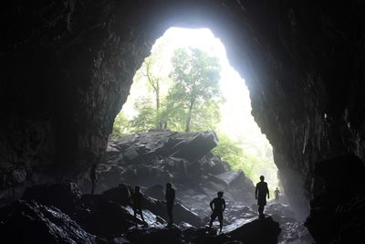
Jam Up Cave on the upper Jacks Fork River.