• Home
  • About
    • About
    • Directions
    • Advertising
    • MSR Facebook Group
    • MSR Lost and Found Group
    • Buy Me A Coffee
    • Contact
  • See & Do!
    • The Master List
    • The Best Float Trips
    • Food & Drink
    • Shop Local (Retail)
    • Hiking & Backpacking
    • MSR Swimming Spots
    • Popular Past Posts
    • Fishing Links
    • Catch of a Lifetime
    • The Flying W Bluff
    • Float into Cave Spring
    • Experience the Transition
    • See Rocky Falls
    • Jacks Fork Artesian Well
    • 2024 Total Eclipse
    • Road Trip to Summersville
    • See Kangaroos + a Cave!
    • MSR Paranormal Stories
  • Lodging
    • Upper Current Lodging
    • 2022 Gravel Bar Survey CA
    • 2022 Gravel Bar Survey AP
    • Lower Current Lodging
    • Jacks Fork Lodging
    • Eleven Point Lodging
    • Options with RV Hook-Ups
    • Options that allow Pets
    • Camping Checklist
  • Outfitters
    • Shuttle Rates
    • How the Outfitters Work
    • Upper Current Outfitters
    • Lower Current Outfitters
    • Current Float Schedule
    • Jacks Fork Outfitters
    • Jacks Fork Float Schedule
    • ONSR Horsepower Limits
    • 11 Point Outfitters
    • 11 Point Float Schedule
    • 11 Point Horsepower Limit
    • 11 Pt. Video Tour (19 mi)
  • Maps
    • Buy ONSR Waterproof Map
    • Where is the MSR region?
    • Where are the 3 MSRs?
    • ONSR Zoomable Map
    • Montauk State Park Map
    • Echo Bluff State Park Map
    • Current River S.P. Map
    • Round Spring Map
    • Big Spring Map
    • Current Mile-by -Mile
    • Alley Spring Map
    • Jacks Fork Mile by Mile
    • 11 Point Clickable Map
    • 11 Point River Map
    • 11 Point Mile by Mile
    • 11 Point Travel Guide
  • Weather
    • Missouri Radar Map
    • Upper Current Weather
    • Middle Current Weather
    • Lower Current Weather
    • Jacks Fork Weather
    • Eleven Point Weather
    • Current River Levels
    • Jacks Fork River Levels
    • Eleven Point River Levels
  • Parks
    • Fishing Limits & Restric.
    • ONSR Website
    • Buy ONSR Map
    • ONSR Alerts & Conditions
    • ONSR Facebook Page
    • ONSR Hunting
    • ONSR Photo Gallery
    • ONSR Laws & Policies
    • ATV & Off Road Vehicles
    • Montauk State Park
    • Montauk Campground Tour
    • Montauk State Park Map
    • Montauk S.P. FB Group
    • Montauk Events Calendar
    • 2021 Montauk Talks
    • Current River State Park
    • Current River S.P. Tour
    • Current River S.P. Map
    • Echo Bluff State Park
    • Echo Bluff State Park Map
  • Caves & Springs
    • Current River Caves
    • Jacks Fork Caves
    • Cave Links
    • Devils Well Research
    • Current River Springs
    • Jacks Fork Springs
    • Eleven Point Springs
    • Spring Links
  • Wild Horses & Riding
    • Horseback Riding ONSR
    • Best ONSR Horse Trails
    • ONSR Horse Trails Map
    • Find Missouri Wild Horses
    • Wild Horses Posts & Pics
    • MO Wild Horse League
  • Camping Games
    • Cornhole
    • Tossing Games Forum
    • Camping Games
  • Historical
    • History Topics (MUST SEE)
    • ONSR History
    • Remembering Cedar Grove
    • Shannon County Genealogy
    • Shannon County Videos
    • Shannon County Museum
    • Oregon County Genealogy
    • Traditional Ozark Crafts
    • Place Names
    • Pulltite History
    • Blair Creek - Henry Gore
    • Portrait of Ozarks Part 1
    • Portrait of Ozarks Part 2
    • New Documentary - Filming
  • Polls
    • Most kid friendly stretch
    • Fav Upper Current Stretch
    • Favorite Month to Visit
    • Favorite way to Sleep
    • Preferred Tubing Mileage?
    • Favorite River?
    • Favorite Watercraft?
    • Upper Current Outfitter
    • Jacks Fork Outfitter
    • Eleven Point Outfitter
  • Best Kayak or Canoe?
    • Best Canoe?
    • Best Kayak or Canoe?
    • Sit in or Sit on Kayak?
    • Best 10 ft. Kayak?
    • Kayak Recommendations
    • Best heavy person kayak?
    • Beginner Kayak buying
    • Best place to buy one?
  • Tragedies & Memoriam
    • 1800s Montauk Killing
    • 1884 Jacks Fork Accident
    • 1896 Current Drowning
    • Welch Spring Tragedy
    • 1913 Jacks Fork Drownings
    • 1957 Fremont Devastation
    • 1966 Rescue
    • 2019 Jacks Fork Rescue
    • 2020 Brewer Tragedy
    • Disasters on the River
    • Lightning Tragedy
    • Mayor Jim Anderson
    • Eleanor Maggard
    • Joe Devall
    • Jack Peters
    • Gene Maggard
    • Marcus Maggard
    • Ranger Bill Terry
    • Jerry Richards
  • More
    • Home
    • About
      • About
      • Directions
      • Advertising
      • MSR Facebook Group
      • MSR Lost and Found Group
      • Buy Me A Coffee
      • Contact
    • See & Do!
      • The Master List
      • The Best Float Trips
      • Food & Drink
      • Shop Local (Retail)
      • Hiking & Backpacking
      • MSR Swimming Spots
      • Popular Past Posts
      • Fishing Links
      • Catch of a Lifetime
      • The Flying W Bluff
      • Float into Cave Spring
      • Experience the Transition
      • See Rocky Falls
      • Jacks Fork Artesian Well
      • 2024 Total Eclipse
      • Road Trip to Summersville
      • See Kangaroos + a Cave!
      • MSR Paranormal Stories
    • Lodging
      • Upper Current Lodging
      • 2022 Gravel Bar Survey CA
      • 2022 Gravel Bar Survey AP
      • Lower Current Lodging
      • Jacks Fork Lodging
      • Eleven Point Lodging
      • Options with RV Hook-Ups
      • Options that allow Pets
      • Camping Checklist
    • Outfitters
      • Shuttle Rates
      • How the Outfitters Work
      • Upper Current Outfitters
      • Lower Current Outfitters
      • Current Float Schedule
      • Jacks Fork Outfitters
      • Jacks Fork Float Schedule
      • ONSR Horsepower Limits
      • 11 Point Outfitters
      • 11 Point Float Schedule
      • 11 Point Horsepower Limit
      • 11 Pt. Video Tour (19 mi)
    • Maps
      • Buy ONSR Waterproof Map
      • Where is the MSR region?
      • Where are the 3 MSRs?
      • ONSR Zoomable Map
      • Montauk State Park Map
      • Echo Bluff State Park Map
      • Current River S.P. Map
      • Round Spring Map
      • Big Spring Map
      • Current Mile-by -Mile
      • Alley Spring Map
      • Jacks Fork Mile by Mile
      • 11 Point Clickable Map
      • 11 Point River Map
      • 11 Point Mile by Mile
      • 11 Point Travel Guide
    • Weather
      • Missouri Radar Map
      • Upper Current Weather
      • Middle Current Weather
      • Lower Current Weather
      • Jacks Fork Weather
      • Eleven Point Weather
      • Current River Levels
      • Jacks Fork River Levels
      • Eleven Point River Levels
    • Parks
      • Fishing Limits & Restric.
      • ONSR Website
      • Buy ONSR Map
      • ONSR Alerts & Conditions
      • ONSR Facebook Page
      • ONSR Hunting
      • ONSR Photo Gallery
      • ONSR Laws & Policies
      • ATV & Off Road Vehicles
      • Montauk State Park
      • Montauk Campground Tour
      • Montauk State Park Map
      • Montauk S.P. FB Group
      • Montauk Events Calendar
      • 2021 Montauk Talks
      • Current River State Park
      • Current River S.P. Tour
      • Current River S.P. Map
      • Echo Bluff State Park
      • Echo Bluff State Park Map
    • Caves & Springs
      • Current River Caves
      • Jacks Fork Caves
      • Cave Links
      • Devils Well Research
      • Current River Springs
      • Jacks Fork Springs
      • Eleven Point Springs
      • Spring Links
    • Wild Horses & Riding
      • Horseback Riding ONSR
      • Best ONSR Horse Trails
      • ONSR Horse Trails Map
      • Find Missouri Wild Horses
      • Wild Horses Posts & Pics
      • MO Wild Horse League
    • Camping Games
      • Cornhole
      • Tossing Games Forum
      • Camping Games
    • Historical
      • History Topics (MUST SEE)
      • ONSR History
      • Remembering Cedar Grove
      • Shannon County Genealogy
      • Shannon County Videos
      • Shannon County Museum
      • Oregon County Genealogy
      • Traditional Ozark Crafts
      • Place Names
      • Pulltite History
      • Blair Creek - Henry Gore
      • Portrait of Ozarks Part 1
      • Portrait of Ozarks Part 2
      • New Documentary - Filming
    • Polls
      • Most kid friendly stretch
      • Fav Upper Current Stretch
      • Favorite Month to Visit
      • Favorite way to Sleep
      • Preferred Tubing Mileage?
      • Favorite River?
      • Favorite Watercraft?
      • Upper Current Outfitter
      • Jacks Fork Outfitter
      • Eleven Point Outfitter
    • Best Kayak or Canoe?
      • Best Canoe?
      • Best Kayak or Canoe?
      • Sit in or Sit on Kayak?
      • Best 10 ft. Kayak?
      • Kayak Recommendations
      • Best heavy person kayak?
      • Beginner Kayak buying
      • Best place to buy one?
    • Tragedies & Memoriam
      • 1800s Montauk Killing
      • 1884 Jacks Fork Accident
      • 1896 Current Drowning
      • Welch Spring Tragedy
      • 1913 Jacks Fork Drownings
      • 1957 Fremont Devastation
      • 1966 Rescue
      • 2019 Jacks Fork Rescue
      • 2020 Brewer Tragedy
      • Disasters on the River
      • Lightning Tragedy
      • Mayor Jim Anderson
      • Eleanor Maggard
      • Joe Devall
      • Jack Peters
      • Gene Maggard
      • Marcus Maggard
      • Ranger Bill Terry
      • Jerry Richards

  • Home
  • About
    • About
    • Directions
    • Advertising
    • MSR Facebook Group
    • MSR Lost and Found Group
    • Buy Me A Coffee
    • Contact
  • See & Do!
    • The Master List
    • The Best Float Trips
    • Food & Drink
    • Shop Local (Retail)
    • Hiking & Backpacking
    • MSR Swimming Spots
    • Popular Past Posts
    • Fishing Links
    • Catch of a Lifetime
    • The Flying W Bluff
    • Float into Cave Spring
    • Experience the Transition
    • See Rocky Falls
    • Jacks Fork Artesian Well
    • 2024 Total Eclipse
    • Road Trip to Summersville
    • See Kangaroos + a Cave!
    • MSR Paranormal Stories
  • Lodging
    • Upper Current Lodging
    • 2022 Gravel Bar Survey CA
    • 2022 Gravel Bar Survey AP
    • Lower Current Lodging
    • Jacks Fork Lodging
    • Eleven Point Lodging
    • Options with RV Hook-Ups
    • Options that allow Pets
    • Camping Checklist
  • Outfitters
    • Shuttle Rates
    • How the Outfitters Work
    • Upper Current Outfitters
    • Lower Current Outfitters
    • Current Float Schedule
    • Jacks Fork Outfitters
    • Jacks Fork Float Schedule
    • ONSR Horsepower Limits
    • 11 Point Outfitters
    • 11 Point Float Schedule
    • 11 Point Horsepower Limit
    • 11 Pt. Video Tour (19 mi)
  • Maps
    • Buy ONSR Waterproof Map
    • Where is the MSR region?
    • Where are the 3 MSRs?
    • ONSR Zoomable Map
    • Montauk State Park Map
    • Echo Bluff State Park Map
    • Current River S.P. Map
    • Round Spring Map
    • Big Spring Map
    • Current Mile-by -Mile
    • Alley Spring Map
    • Jacks Fork Mile by Mile
    • 11 Point Clickable Map
    • 11 Point River Map
    • 11 Point Mile by Mile
    • 11 Point Travel Guide
  • Weather
    • Missouri Radar Map
    • Upper Current Weather
    • Middle Current Weather
    • Lower Current Weather
    • Jacks Fork Weather
    • Eleven Point Weather
    • Current River Levels
    • Jacks Fork River Levels
    • Eleven Point River Levels
  • Parks
    • Fishing Limits & Restric.
    • ONSR Website
    • Buy ONSR Map
    • ONSR Alerts & Conditions
    • ONSR Facebook Page
    • ONSR Hunting
    • ONSR Photo Gallery
    • ONSR Laws & Policies
    • ATV & Off Road Vehicles
    • Montauk State Park
    • Montauk Campground Tour
    • Montauk State Park Map
    • Montauk S.P. FB Group
    • Montauk Events Calendar
    • 2021 Montauk Talks
    • Current River State Park
    • Current River S.P. Tour
    • Current River S.P. Map
    • Echo Bluff State Park
    • Echo Bluff State Park Map
  • Caves & Springs
    • Current River Caves
    • Jacks Fork Caves
    • Cave Links
    • Devils Well Research
    • Current River Springs
    • Jacks Fork Springs
    • Eleven Point Springs
    • Spring Links
  • Wild Horses & Riding
    • Horseback Riding ONSR
    • Best ONSR Horse Trails
    • ONSR Horse Trails Map
    • Find Missouri Wild Horses
    • Wild Horses Posts & Pics
    • MO Wild Horse League
  • Camping Games
    • Cornhole
    • Tossing Games Forum
    • Camping Games
  • Historical
    • History Topics (MUST SEE)
    • ONSR History
    • Remembering Cedar Grove
    • Shannon County Genealogy
    • Shannon County Videos
    • Shannon County Museum
    • Oregon County Genealogy
    • Traditional Ozark Crafts
    • Place Names
    • Pulltite History
    • Blair Creek - Henry Gore
    • Portrait of Ozarks Part 1
    • Portrait of Ozarks Part 2
    • New Documentary - Filming
  • Polls
    • Most kid friendly stretch
    • Fav Upper Current Stretch
    • Favorite Month to Visit
    • Favorite way to Sleep
    • Preferred Tubing Mileage?
    • Favorite River?
    • Favorite Watercraft?
    • Upper Current Outfitter
    • Jacks Fork Outfitter
    • Eleven Point Outfitter
  • Best Kayak or Canoe?
    • Best Canoe?
    • Best Kayak or Canoe?
    • Sit in or Sit on Kayak?
    • Best 10 ft. Kayak?
    • Kayak Recommendations
    • Best heavy person kayak?
    • Beginner Kayak buying
    • Best place to buy one?
  • Tragedies & Memoriam
    • 1800s Montauk Killing
    • 1884 Jacks Fork Accident
    • 1896 Current Drowning
    • Welch Spring Tragedy
    • 1913 Jacks Fork Drownings
    • 1957 Fremont Devastation
    • 1966 Rescue
    • 2019 Jacks Fork Rescue
    • 2020 Brewer Tragedy
    • Disasters on the River
    • Lightning Tragedy
    • Mayor Jim Anderson
    • Eleanor Maggard
    • Joe Devall
    • Jack Peters
    • Gene Maggard
    • Marcus Maggard
    • Ranger Bill Terry
    • Jerry Richards

Caves

Current River


NOTE:  ALL CAVES IN THE OZARK NATIONAL SCENIC RIVERWAYS ARE CLOSED TO ENTERING (Except for Guided Tours of Round Spring Cave [when open] and Cave Spring which you can float into at mile marker 21.9 on the upper Current River). This is due to the discovery of White Nose Syndrome, a disease that kills bats, in Shannon County. Please respect these closed caves for the protection of the bats. 


  • Medlock Cave - *Mile Marker 12.6 on right* .   This is located between the Cedar Grove and Akers Ferry stretch.


  • Welch Spring Cave - The cave is barred due to the endangered gray bat.  The cave is located in the remnants of an old run down hospital here that was used to treat patients who had asthma by having them breath the cave air. *Mile Marker 13.7 on left.   This is located between the Cedar Grove and Akers Ferry stretch.


  • Cave Spring Cave (You canoe into it! - video here) - *Mile Marker 21.9 on left* ---> and nearby Devils Well.  Also, this little hike is just below Cave Spring on the left (maybe 5 minutes below right before some rapids). Video here.   --- See this photo of over 100 years ago!   This is located between the Akers Ferry to Pulltite Spring stretch.


  • Rock House Cave - *Mile Marker 24.2 on right*  Also see here.   This is located on the Akers Ferry to Pulltite Spring stretch.


  • Fire Hydrandt (Pulltite) Cave - *Mile Marker 27.3 on right*    This is on the Pulltite Spring to Round Spring stretch.


  • Bat Cave (No Link) - *~Mile Marker 29.0 on left, somewhat fenced due to endangered bats*   This is on the Pulltite Spring to Round Spring stretch.


  • Little Gem Cave (also called Merritt Rock Cave) - *~Mile Marker 31.0*  This is on the Pulltite Spring to Round Spring stretch.


  • Round Spring Cave - *Mile Marker 35.2 on right* Close to the famous spring with the same name, but not connected.


  • Courthouse Cave - *~ Mile Marker 36.2 on right*


DID YOU KNOW? Shannon County has the 2nd most recorded caves in the state. Over 400!!! Perry County is 1st with over 600. Source: Joel Laws, VP - Missouri Speleological Survey 

Cave Spring, Current River

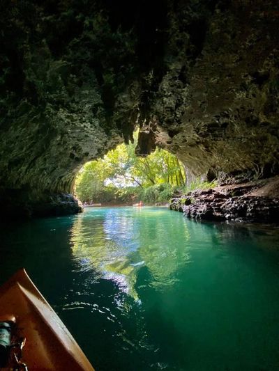
Floating inside Cave Spring on the upper Current River.  Located between Akers Ferry and Pulltite.

Copyright © 2023 - All Rights Reserved.

Veteran Owned Website - Established 2002

  • Home
  • Directions
  • Advertising
  • Buy Me A Coffee
  • Contact
  • Buy ONSR Map
  • Camping Games