• Home
  • About
    • About
    • Directions
    • Advertising
    • MSR Facebook Group
    • MSR Lost and Found Group
    • Buy Me A Coffee
    • Contact
  • See & Do!
    • The Master List
    • The Best Float Trips
    • Food & Drink
    • Shop Local (Retail)
    • Hiking & Backpacking
    • MSR Swimming Spots
    • Popular Past Posts
    • Fishing Links
    • Catch of a Lifetime
    • The Flying W Bluff
    • Float into Cave Spring
    • Experience the Transition
    • See Rocky Falls
    • Jacks Fork Artesian Well
    • 2024 Total Eclipse
    • Road Trip to Summersville
    • See Kangaroos + a Cave!
    • MSR Paranormal Stories
  • Lodging
    • Upper Current Lodging
    • 2022 Gravel Bar Survey CA
    • 2022 Gravel Bar Survey AP
    • Lower Current Lodging
    • Jacks Fork Lodging
    • Eleven Point Lodging
    • Options with RV Hook-Ups
    • Options that allow Pets
    • Camping Checklist
  • Outfitters
    • Shuttle Rates
    • How the Outfitters Work
    • Upper Current Outfitters
    • Lower Current Outfitters
    • Current Float Schedule
    • Jacks Fork Outfitters
    • Jacks Fork Float Schedule
    • ONSR Horsepower Limits
    • 11 Point Outfitters
    • 11 Point Float Schedule
    • 11 Point Horsepower Limit
    • 11 Pt. Video Tour (19 mi)
  • Maps
    • Buy ONSR Waterproof Map
    • Where is the MSR region?
    • Where are the 3 MSRs?
    • ONSR Zoomable Map
    • Montauk State Park Map
    • Echo Bluff State Park Map
    • Current River S.P. Map
    • Round Spring Map
    • Big Spring Map
    • Current Mile-by -Mile
    • Alley Spring Map
    • Jacks Fork Mile by Mile
    • 11 Point Clickable Map
    • 11 Point River Map
    • 11 Point Mile by Mile
    • 11 Point Travel Guide
  • Weather
    • Missouri Radar Map
    • Upper Current Weather
    • Middle Current Weather
    • Lower Current Weather
    • Jacks Fork Weather
    • Eleven Point Weather
    • Current River Levels
    • Jacks Fork River Levels
    • Eleven Point River Levels
  • Parks
    • Fishing Limits & Restric.
    • ONSR Website
    • Buy ONSR Map
    • ONSR Alerts & Conditions
    • ONSR Facebook Page
    • ONSR Hunting
    • ONSR Photo Gallery
    • ONSR Laws & Policies
    • ATV & Off Road Vehicles
    • Montauk State Park
    • Montauk Campground Tour
    • Montauk State Park Map
    • Montauk S.P. FB Group
    • Montauk Events Calendar
    • 2021 Montauk Talks
    • Current River State Park
    • Current River S.P. Tour
    • Current River S.P. Map
    • Echo Bluff State Park
    • Echo Bluff State Park Map
  • Caves & Springs
    • Current River Caves
    • Jacks Fork Caves
    • Cave Links
    • Devils Well Research
    • Current River Springs
    • Jacks Fork Springs
    • Eleven Point Springs
    • Spring Links
  • Wild Horses & Riding
    • Horseback Riding ONSR
    • Best ONSR Horse Trails
    • ONSR Horse Trails Map
    • Find Missouri Wild Horses
    • Wild Horses Posts & Pics
    • MO Wild Horse League
  • Camping Games
    • Cornhole
    • Tossing Games Forum
    • Camping Games
  • Historical
    • History Topics (MUST SEE)
    • ONSR History
    • Remembering Cedar Grove
    • Shannon County Genealogy
    • Shannon County Videos
    • Shannon County Museum
    • Oregon County Genealogy
    • Traditional Ozark Crafts
    • Place Names
    • Pulltite History
    • Blair Creek - Henry Gore
    • Portrait of Ozarks Part 1
    • Portrait of Ozarks Part 2
    • New Documentary - Filming
  • Polls
    • Most kid friendly stretch
    • Fav Upper Current Stretch
    • Favorite Month to Visit
    • Favorite way to Sleep
    • Preferred Tubing Mileage?
    • Favorite River?
    • Favorite Watercraft?
    • Upper Current Outfitter
    • Jacks Fork Outfitter
    • Eleven Point Outfitter
  • Best Kayak or Canoe?
    • Best Canoe?
    • Best Kayak or Canoe?
    • Sit in or Sit on Kayak?
    • Best 10 ft. Kayak?
    • Kayak Recommendations
    • Best heavy person kayak?
    • Beginner Kayak buying
    • Best place to buy one?
  • Tragedies & Memoriam
    • 1800s Montauk Killing
    • 1884 Jacks Fork Accident
    • 1896 Current Drowning
    • Welch Spring Tragedy
    • 1913 Jacks Fork Drownings
    • 1957 Fremont Devastation
    • 1966 Rescue
    • 2019 Jacks Fork Rescue
    • 2020 Brewer Tragedy
    • Disasters on the River
    • Lightning Tragedy
    • Mayor Jim Anderson
    • Eleanor Maggard
    • Joe Devall
    • Jack Peters
    • Gene Maggard
    • Marcus Maggard
    • Ranger Bill Terry
    • Jerry Richards
  • More
    • Home
    • About
      • About
      • Directions
      • Advertising
      • MSR Facebook Group
      • MSR Lost and Found Group
      • Buy Me A Coffee
      • Contact
    • See & Do!
      • The Master List
      • The Best Float Trips
      • Food & Drink
      • Shop Local (Retail)
      • Hiking & Backpacking
      • MSR Swimming Spots
      • Popular Past Posts
      • Fishing Links
      • Catch of a Lifetime
      • The Flying W Bluff
      • Float into Cave Spring
      • Experience the Transition
      • See Rocky Falls
      • Jacks Fork Artesian Well
      • 2024 Total Eclipse
      • Road Trip to Summersville
      • See Kangaroos + a Cave!
      • MSR Paranormal Stories
    • Lodging
      • Upper Current Lodging
      • 2022 Gravel Bar Survey CA
      • 2022 Gravel Bar Survey AP
      • Lower Current Lodging
      • Jacks Fork Lodging
      • Eleven Point Lodging
      • Options with RV Hook-Ups
      • Options that allow Pets
      • Camping Checklist
    • Outfitters
      • Shuttle Rates
      • How the Outfitters Work
      • Upper Current Outfitters
      • Lower Current Outfitters
      • Current Float Schedule
      • Jacks Fork Outfitters
      • Jacks Fork Float Schedule
      • ONSR Horsepower Limits
      • 11 Point Outfitters
      • 11 Point Float Schedule
      • 11 Point Horsepower Limit
      • 11 Pt. Video Tour (19 mi)
    • Maps
      • Buy ONSR Waterproof Map
      • Where is the MSR region?
      • Where are the 3 MSRs?
      • ONSR Zoomable Map
      • Montauk State Park Map
      • Echo Bluff State Park Map
      • Current River S.P. Map
      • Round Spring Map
      • Big Spring Map
      • Current Mile-by -Mile
      • Alley Spring Map
      • Jacks Fork Mile by Mile
      • 11 Point Clickable Map
      • 11 Point River Map
      • 11 Point Mile by Mile
      • 11 Point Travel Guide
    • Weather
      • Missouri Radar Map
      • Upper Current Weather
      • Middle Current Weather
      • Lower Current Weather
      • Jacks Fork Weather
      • Eleven Point Weather
      • Current River Levels
      • Jacks Fork River Levels
      • Eleven Point River Levels
    • Parks
      • Fishing Limits & Restric.
      • ONSR Website
      • Buy ONSR Map
      • ONSR Alerts & Conditions
      • ONSR Facebook Page
      • ONSR Hunting
      • ONSR Photo Gallery
      • ONSR Laws & Policies
      • ATV & Off Road Vehicles
      • Montauk State Park
      • Montauk Campground Tour
      • Montauk State Park Map
      • Montauk S.P. FB Group
      • Montauk Events Calendar
      • 2021 Montauk Talks
      • Current River State Park
      • Current River S.P. Tour
      • Current River S.P. Map
      • Echo Bluff State Park
      • Echo Bluff State Park Map
    • Caves & Springs
      • Current River Caves
      • Jacks Fork Caves
      • Cave Links
      • Devils Well Research
      • Current River Springs
      • Jacks Fork Springs
      • Eleven Point Springs
      • Spring Links
    • Wild Horses & Riding
      • Horseback Riding ONSR
      • Best ONSR Horse Trails
      • ONSR Horse Trails Map
      • Find Missouri Wild Horses
      • Wild Horses Posts & Pics
      • MO Wild Horse League
    • Camping Games
      • Cornhole
      • Tossing Games Forum
      • Camping Games
    • Historical
      • History Topics (MUST SEE)
      • ONSR History
      • Remembering Cedar Grove
      • Shannon County Genealogy
      • Shannon County Videos
      • Shannon County Museum
      • Oregon County Genealogy
      • Traditional Ozark Crafts
      • Place Names
      • Pulltite History
      • Blair Creek - Henry Gore
      • Portrait of Ozarks Part 1
      • Portrait of Ozarks Part 2
      • New Documentary - Filming
    • Polls
      • Most kid friendly stretch
      • Fav Upper Current Stretch
      • Favorite Month to Visit
      • Favorite way to Sleep
      • Preferred Tubing Mileage?
      • Favorite River?
      • Favorite Watercraft?
      • Upper Current Outfitter
      • Jacks Fork Outfitter
      • Eleven Point Outfitter
    • Best Kayak or Canoe?
      • Best Canoe?
      • Best Kayak or Canoe?
      • Sit in or Sit on Kayak?
      • Best 10 ft. Kayak?
      • Kayak Recommendations
      • Best heavy person kayak?
      • Beginner Kayak buying
      • Best place to buy one?
    • Tragedies & Memoriam
      • 1800s Montauk Killing
      • 1884 Jacks Fork Accident
      • 1896 Current Drowning
      • Welch Spring Tragedy
      • 1913 Jacks Fork Drownings
      • 1957 Fremont Devastation
      • 1966 Rescue
      • 2019 Jacks Fork Rescue
      • 2020 Brewer Tragedy
      • Disasters on the River
      • Lightning Tragedy
      • Mayor Jim Anderson
      • Eleanor Maggard
      • Joe Devall
      • Jack Peters
      • Gene Maggard
      • Marcus Maggard
      • Ranger Bill Terry
      • Jerry Richards

  • Home
  • About
    • About
    • Directions
    • Advertising
    • MSR Facebook Group
    • MSR Lost and Found Group
    • Buy Me A Coffee
    • Contact
  • See & Do!
    • The Master List
    • The Best Float Trips
    • Food & Drink
    • Shop Local (Retail)
    • Hiking & Backpacking
    • MSR Swimming Spots
    • Popular Past Posts
    • Fishing Links
    • Catch of a Lifetime
    • The Flying W Bluff
    • Float into Cave Spring
    • Experience the Transition
    • See Rocky Falls
    • Jacks Fork Artesian Well
    • 2024 Total Eclipse
    • Road Trip to Summersville
    • See Kangaroos + a Cave!
    • MSR Paranormal Stories
  • Lodging
    • Upper Current Lodging
    • 2022 Gravel Bar Survey CA
    • 2022 Gravel Bar Survey AP
    • Lower Current Lodging
    • Jacks Fork Lodging
    • Eleven Point Lodging
    • Options with RV Hook-Ups
    • Options that allow Pets
    • Camping Checklist
  • Outfitters
    • Shuttle Rates
    • How the Outfitters Work
    • Upper Current Outfitters
    • Lower Current Outfitters
    • Current Float Schedule
    • Jacks Fork Outfitters
    • Jacks Fork Float Schedule
    • ONSR Horsepower Limits
    • 11 Point Outfitters
    • 11 Point Float Schedule
    • 11 Point Horsepower Limit
    • 11 Pt. Video Tour (19 mi)
  • Maps
    • Buy ONSR Waterproof Map
    • Where is the MSR region?
    • Where are the 3 MSRs?
    • ONSR Zoomable Map
    • Montauk State Park Map
    • Echo Bluff State Park Map
    • Current River S.P. Map
    • Round Spring Map
    • Big Spring Map
    • Current Mile-by -Mile
    • Alley Spring Map
    • Jacks Fork Mile by Mile
    • 11 Point Clickable Map
    • 11 Point River Map
    • 11 Point Mile by Mile
    • 11 Point Travel Guide
  • Weather
    • Missouri Radar Map
    • Upper Current Weather
    • Middle Current Weather
    • Lower Current Weather
    • Jacks Fork Weather
    • Eleven Point Weather
    • Current River Levels
    • Jacks Fork River Levels
    • Eleven Point River Levels
  • Parks
    • Fishing Limits & Restric.
    • ONSR Website
    • Buy ONSR Map
    • ONSR Alerts & Conditions
    • ONSR Facebook Page
    • ONSR Hunting
    • ONSR Photo Gallery
    • ONSR Laws & Policies
    • ATV & Off Road Vehicles
    • Montauk State Park
    • Montauk Campground Tour
    • Montauk State Park Map
    • Montauk S.P. FB Group
    • Montauk Events Calendar
    • 2021 Montauk Talks
    • Current River State Park
    • Current River S.P. Tour
    • Current River S.P. Map
    • Echo Bluff State Park
    • Echo Bluff State Park Map
  • Caves & Springs
    • Current River Caves
    • Jacks Fork Caves
    • Cave Links
    • Devils Well Research
    • Current River Springs
    • Jacks Fork Springs
    • Eleven Point Springs
    • Spring Links
  • Wild Horses & Riding
    • Horseback Riding ONSR
    • Best ONSR Horse Trails
    • ONSR Horse Trails Map
    • Find Missouri Wild Horses
    • Wild Horses Posts & Pics
    • MO Wild Horse League
  • Camping Games
    • Cornhole
    • Tossing Games Forum
    • Camping Games
  • Historical
    • History Topics (MUST SEE)
    • ONSR History
    • Remembering Cedar Grove
    • Shannon County Genealogy
    • Shannon County Videos
    • Shannon County Museum
    • Oregon County Genealogy
    • Traditional Ozark Crafts
    • Place Names
    • Pulltite History
    • Blair Creek - Henry Gore
    • Portrait of Ozarks Part 1
    • Portrait of Ozarks Part 2
    • New Documentary - Filming
  • Polls
    • Most kid friendly stretch
    • Fav Upper Current Stretch
    • Favorite Month to Visit
    • Favorite way to Sleep
    • Preferred Tubing Mileage?
    • Favorite River?
    • Favorite Watercraft?
    • Upper Current Outfitter
    • Jacks Fork Outfitter
    • Eleven Point Outfitter
  • Best Kayak or Canoe?
    • Best Canoe?
    • Best Kayak or Canoe?
    • Sit in or Sit on Kayak?
    • Best 10 ft. Kayak?
    • Kayak Recommendations
    • Best heavy person kayak?
    • Beginner Kayak buying
    • Best place to buy one?
  • Tragedies & Memoriam
    • 1800s Montauk Killing
    • 1884 Jacks Fork Accident
    • 1896 Current Drowning
    • Welch Spring Tragedy
    • 1913 Jacks Fork Drownings
    • 1957 Fremont Devastation
    • 1966 Rescue
    • 2019 Jacks Fork Rescue
    • 2020 Brewer Tragedy
    • Disasters on the River
    • Lightning Tragedy
    • Mayor Jim Anderson
    • Eleanor Maggard
    • Joe Devall
    • Jack Peters
    • Gene Maggard
    • Marcus Maggard
    • Ranger Bill Terry
    • Jerry Richards

SPRINGS

ELEVEN POINT RIVER

  • Falling Spring - Also see video here.    Not accessible from the river.   From Alton, MO travel North on MO Hwy 19 approx. 16.3 miles. Turn Right/East onto FR#3170. This road immediately splits; follow FR#3164 to your Left. Keep right at an intersection at approx 2 miles, then Falling Spring will be on your right at approx. 2.3.   One of the more photographed spots in the Mark Twain National Forest, the Falling Spring Picnic Area offers history, scenic beauty, and quiet relaxation. This day-use area is situated on the edge of a spring-fed pond that falls from out of the middle of a small bluff wall. This spring, which is also a waterfall, has provided power for two mills in the past, the second of which still stands today. Built in the 1920s, this mill provided electricity, ground corn, and even sawed lumber and shingles for the few local residents. A small wooden walkway leads to the mill for closer inspection, which still has some of its original machinery in place.   Aside from a few picnic tables and a small parking area, Falling Spring Picnic Area also holds an historic log cabin over 100 years old. Built in the mid-to-late 1800s, this cabin is the first of four houses built near this site. Constructed with half-dovetail notches at the corners, this helps to shed water away from the cabin, and may be one reason why it still stands today.


  • Greer Spring -  On right after put in on Greer to Turner Mill stretch.   Second largest spring within the state, is surrounded by walking fern and other vegetation in its natural state. The main outlet boils from its basin and plunges down the hillside to the Eleven Point River 1.25 miles away. The average flow is more than 300 cubic feet per second and the drop is 62 feet. However, a raft run down the spring several years ago resulted in a drowning. The spring is on private property and has been graciously left open to the public, but permission to float the spring will not be given. Greer Spring nearly doubles the size of the river and makes the Eleven Point River below Hwy. 19 quite floatable even in dry years. An 11-mile section of the river below Greer Spring is managed by MDC for rainbow trout. An area known as The Irish Wilderness, through which the river runs, is well named and indicates the character of this cool, fast river.    


  • Turner Mill & Spring - Located 5.5 miles below Greer Spring.   Access on both sides of the river.  You can do Greer to Turner or Turner to Riverton stretch to check this out.


  • Boze Mill & Spring - Located on left.  Located 12 miles below Tuner Mill and about 2 miles before you get to the Riverton hwy 160 bridge.    Located on the Turner Mill to Riverton stretch.


  • Blue Spring - 8th largest spring in the state.   Located just 0.3 miles before the hwy 142 bridge. 


Falling Spring - Eleven Point River

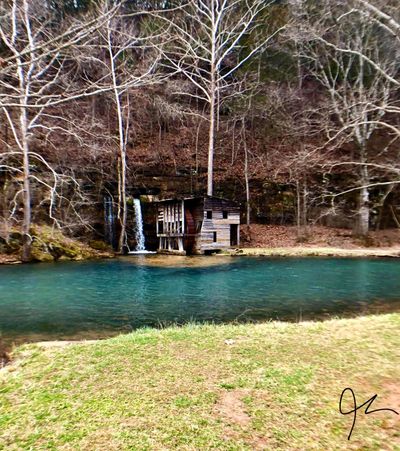
Falling Spring  - Photo Credit Jackson Lloyd.

Copyright © 2023 - All Rights Reserved.

Veteran Owned Website - Established 2002

  • Home
  • Directions
  • Advertising
  • Buy Me A Coffee
  • Contact
  • Buy ONSR Map
  • Camping Games